


California received statehood on September 9, 1850 and is known as “The Golden State” due to its long association with gold. It refers to The California Gold Rush of 1848, and the yellow poppies that bloom in the springtime. It is home to the world’s oldest trees, the bristlecone pines, the biggest trees, the sequoias, and the tallest trees, the redwoods.
Here are some of the things we learned about this week:
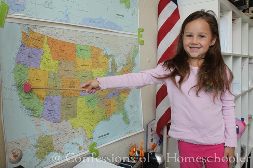
- Located California on our wall map
- Read our National Geographic Atlas and located Sacramento, CA using the map coordinates.
- Worked on our 50 States and Capitals song
- Learned about the state and it’s flag
- State Bird: California Quail
- State Fish: Golden Trout
- State Flower: The Poppy
- State Insect: The Dogface Butterfly
- Famous Landmarks: Golden Gate Bridge & Alcatraz Island
- U.S. Presidents Richard Nixon
- Famous People: Robert Frost & General George S. Patton Jr.
- Food: California is famous for its avocadoes, figs and Navel and Valencia oranges.
Here is my white board for the week, we use this to review all of the state facts and symbols each day.

We read through our California Highlights magazine to get inspiration for our postcard and learn some other fun and interesting state facts.

We made a California state postcard to send to an imaginary friend…


Turbo added California to our United States Bulletin. After that we reviewed all of the states we’ve learned so far on our travels.

After learning about the animals symbols for California , we classified and added the animals to our USA animal wall!


We took turns locating Phoenix, California in our National Geographic Atlas.

They all completed their state worksheets as we read through all of the California state facts in our curriculum:


Then Turbo had the honor of adding the state to our wall map.

Golden Gate Bridge: The Golden Gate bridge opened in San Francisco in 1937. It is 1.7 miles long and 90 feet wide. It is 220 feet above the water. Only 11 workers died during construction which was a new safety record for the time. They had expected about 35 deaths. One of the safety precautions taken was a net suspended under the floor which saved 19 lives. Click here to learn more! And Visit www.gocaliforna.about.com for even more facts on the Golden Gate Bridge.

Alcatraz Island: Alcatraz island is known as “The Rock” , it was a maximum security prison in the bay of San Francisco. Each cell was 5 x 9 feet. They had a small sink with cold running water, a small sleeping cot and a toilet. Most men could reach out with both arms and touch each wall with their arms. They could have 1 approved visitor per month. They were not allowed any physical conduct and talked through intercoms. Although several escape attempts were made, officially speaking, no one ever succeeded in escaping from Alcatraz. Out of 36 attempts, 23 were caught, 6 were shot and killed and 2 drowned. There are 5 prisoners listed as “missing and presumed drowned”. Learn more from www.alcatrazhistory.com

U.S. President: Richard Nixon, the 37th President of the U.S. (1969-1974) was born January 9, 1919 in Yorba Linda, CA.

Of course we concluded our study by adding the California state flag to our Travel Journal!

And since it was a review week, we added Alaska and California to our notebooking page.

And that wraps up our California study! If you’d like to come along with us on our Road Trip USA journey, click the image below to learn more!

Nice homage to the place where I was born, raised, and remain. I love CA! Put your finger about a half inch below Sacramento on your notebook map and there we are 🙂
~Kendra
Yay for California! That is my state too:)
The Moffatt Girls
My neighbor gave me a complete set of the Highlights State magazines. We have loved them – especially since we are a military family and we move around a lot.
My brother did this with his daughter on all their cross country vacations. My niece has several binders full of essays she wrote about different places, digital photos she took, and keepsakes purchased. She loves to get them out and share them with anyone who comes over. It is truly an educational experience.
How fun! I live in the San Francisco Bay Area! I love my beautiful California.
yay- California (our state!)
I love the detail of this study…so much to learn, so many interesting facts, and you guys are covering it all! 🙂
Good job.
Is it ok to print a apple activity and use it with my homeschool co op for k-1 students? I believe we will have about 6 children. I just wanted a extra activity for them to do. Thanks!
I LOVE this. My family and I took a trip from coast to coast earlier this year. I made things LIKE this for my children for each state that we passed through. I am going to be blogging about it in the next week or so… Would you mind if I linked up some of your “Road Trip” stuff as well? We did basically the same thing, in different ways. 🙂
Love your different “road trips”–really fun ideas. Like Kendra, I’m a California girl. We live within a hour of mountains, desert, beach, and … Disneyland!
Hello! I love it all! I am printing off the calendar, chore pack, lots this week! Thank you for all your hard work to make my new endeavor of homeschooling so much easier….and cheaper! 🙂 I’m looking for the perfect U.S. Map. Where did you find the one that is in pieces that Turbo added California to? That looks more interactive than the small wooden ones. I followed the link, but couldn’t find it. Sorry…. Did you just cut them and laminate? Thanks so much!
P.S. We’re from Illinois, and it’s been hard to have state pride lately…so this will be great to look to our past and remember why we rock! We’re planning a trip to Salem (Lincoln’s hometown) soon. We kinda have to go that far back. hehe