


South Dakota was named the 40th state on November 2, 1889. It is known as “The Mount Rushmore State” because It is home to Mount Rushmore National Monument, located in Black Hills National Forest. The monument took 14 years and $1 million to complete.
Here are some of the things we learned about this week:
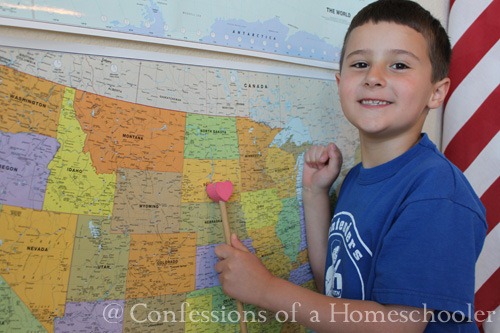
- Located South Dakota on our wall map
- Read our National Geographic Atlas and located Pierre, SD using the map coordinates.
- Worked on our 50 States and Capitals song
- Learned about the state and it’s flag
- State Bird: Chinese Ring-Necked Pheasant
- State Flower: American Pasque
- State Animal: Coyote
- Famous Landmarks: Mount Rushmore & Badlands National Park
- Food: Kuchen
- Recipe: We made a yummy Apple Kuchen for this week! (Recipe included in Road Trip USA)
First we located the state and it’s capital on our wall map, next we took turns locating Pierre, South Dakota in our National Geographic Atlas.
Mount Rushmore is the world’s greatest mountain carving, sculpted with the faces of George Washington, Thomas Jefferson, Theodore Roosevelt, and Abraham Lincoln. The entire memorial covers 1,278 acres and is 5,725 feet above sea level. The project started in 1927, and was completed in 1941 with some injuries but no fatalities. The entire project cost $1 million to complete. It is controversial among Native Americans because the United States seized the area from the Lakota tribe after the Great Sioux War of 1876-77. The Treaty of Fort Laramie (1868) had previously granted the Black Hills to the Lakota. In 1971 the American Indian Movement lead an occupation of the monument, naming it “Mount Crazy Horse”.
Badlands National Park is in southwest South Dakota and preserves 244,000 acres of buttes, pinnacles, and spires blended with the largest protected mixed grass prairie in the U.S. Native Americans have historically used this area for their hunting grounds. From the top of the Badlands Wall, they could scan the area for enemies and wandering herds. In the 19th century homesteaders moved into S.D. and the U.S. government stripped Native Americans of much of their territory forcing them to live on reservations. On November 10, 1978 the area was re-designated as a National Park.
Tinker Bell add South Dakota to our United States Bulletin. After that we reviewed all of the states we’ve learned so far on our travels.
The kids had a chance to color in their state worksheets as we read through all of our information for South Dakota .
After learning about the animals symbols for South Dakota, we classified and added the animals to our USA animal wall!
Then Strawberry Shortcake had the honor of adding the state to our wall map.
And that ended our journey in South Dakota, we sealed the deal by adding the state flag to our Travel Journal.
And that wraps up our South Dakota study! If you’d like to come along with us on our Road Trip USA journey, click the image below to learn more!


Do you think it is necessary to have both wall maps or is it just to be repetitive for memorization?
Well timed Erica! Monkey decided earlier this week that he was going to run away from home, steal a car, then make a pilot fly him to South Dakota… being that he is a Canadian from central Ontario, it was more than a little amusing. Now I can teach him a bit about it… Thanks!
Very curious about this part:
“Read our National Geographic Atlas and located Bismark, SD using the map coordinates.” Bismark is in North Dakota, not South Dakota.
Amelia,
Thank you for letting me know about the typo in my post. I fixed it. It should have said Pierre and not Bismarck. Erica
I want to do this for my school this fall and wonder, did you write to the states for information, or did you just use resources online and library. If from states, who did you write to??